Kex Gill is a name that carries considerable weight in North Yorkshire. For decades, it has represented both a vital transport corridor and one of the most persistent road engineering challenges in northern England. Located on the A59 between Harrogate and Skipton, Kex Gill is not simply a point on a map; it is a place where geology, weather, history, and modern infrastructure collide. Motorists, local residents, engineers, and planners alike have all been affected by its unique conditions.
Where Kex Gill Is Located
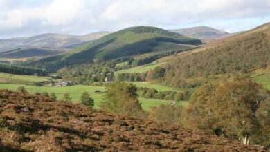
Kex Gill lies in the upland countryside of North Yorkshire, close to the village of Blubberhouses and on the edge of the Nidderdale landscape. The area sits within a high moorland environment, characterised by open views, exposed slopes, and rapidly changing weather conditions. The road through Kex Gill carries the A59, an important east–west route linking communities, businesses, and tourism centres across the region.
The location is visually striking but technically challenging. Steep embankments, peat-rich soils, and natural water movement combine to create an environment that is inherently unstable. These natural features define the character of Kex Gill and explain many of the difficulties faced by engineers over the years.
The Meaning and Background of the Name
The name “Kex Gill” reflects the area’s natural heritage. “Gill” is a northern English term describing a narrow valley or ravine, often with a stream running through it. “Kex” is believed to refer to wild plants historically common in the area. Together, the name suggests a natural landscape shaped by water and vegetation, long before modern roads were introduced.
Understanding this background is important, as it highlights that Kex Gill was never a stable or static environment. The road that passes through it was laid across land that had always been moving and changing, even if that movement was not immediately visible.
Geological Conditions at Kex Gill
One of the defining features of Kex Gill is its geology. The ground consists largely of peat and clay layers sitting above more solid rock. Peat, while rich in organic material, is highly susceptible to water saturation. When heavy rainfall occurs, the peat absorbs water, increases in weight, and becomes unstable.
This instability has led to repeated landslips over many years. In some cases, entire sections of road have cracked, shifted, or dropped, making them unsafe for traffic. Unlike surface-level damage, these movements often originate deep below the road, making repairs complex and temporary.
The geology of Kex Gill explains why conventional maintenance solutions have failed time and again. Resurfacing alone cannot solve a problem rooted in the ground beneath the tarmac.
The Importance of the A59 Through Kex Gill
The A59 is one of North Yorkshire’s most important roads. It connects major settlements, supports local commerce, and serves tourists travelling to scenic rural areas. For many drivers, the route through Kex Gill is the most direct and efficient way to travel between key destinations.
When this section of road is closed or restricted, the impact is immediate. Detours can add significant time to journeys, increase congestion on smaller roads, and disrupt local communities. Businesses dependent on reliable transport links also feel the effects, particularly those involved in tourism, agriculture, and logistics.
Kex Gill therefore represents a critical point of vulnerability within the wider transport network.
A History of Road Closures and Repairs
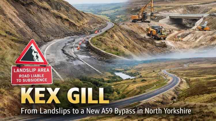
Over the years, Kex Gill has become synonymous with road closures. Periods of heavy rain have often triggered landslips, forcing authorities to shut the road for safety reasons. Temporary repairs have included stabilisation works, drainage improvements, and resurfacing.
Despite best efforts, these measures have rarely provided long-term solutions. In some cases, newly repaired sections have failed within months. This cycle of damage and repair has been costly and frustrating, leading to widespread recognition that a more permanent approach was needed.
The history of Kex Gill is therefore one of persistence, with engineers continually adapting their methods while acknowledging the limits imposed by nature.
Environmental Sensitivity of the Area
Kex Gill is not only a transport route but also part of a sensitive natural environment. The surrounding moorland supports wildlife, plant life, and water systems that require careful management. Any large-scale engineering project in the area must consider its environmental impact.
Water management is particularly important. Altering drainage patterns can affect peat stability, nearby habitats, and downstream watercourses. Balancing the need for a reliable road with the protection of the natural landscape has been a central challenge in planning long-term solutions for Kex Gill.
The Decision to Realign the Road
After decades of repeated failures, authorities concluded that maintaining the existing route was no longer viable. The decision was made to realign the road onto more stable ground, avoiding the most landslip-prone areas altogether.
This approach marked a shift in strategy. Rather than fighting against the natural behaviour of the land, the new plan works with it by selecting a route better suited to long-term stability. The realignment represents one of the most significant transport projects in North Yorkshire in recent years.
Engineering Challenges of the Realignment
Designing a new route near Kex Gill has involved complex engineering. Surveyors and geologists have carefully assessed ground conditions to identify areas capable of supporting a modern road. Advanced drainage systems have been incorporated to manage surface water and reduce pressure on the ground.
Construction in an exposed upland environment presents additional challenges. Weather conditions can limit working windows, and access to remote areas requires careful planning. Despite these difficulties, the project reflects modern engineering practices designed to deliver a durable and safe transport link.
Benefits for Safety and Reliability
One of the main objectives of the Kex Gill realignment is improved safety. Landslip-related road failures pose serious risks to motorists, particularly in poor visibility or adverse weather. A stable route reduces the likelihood of sudden closures and unexpected hazards.
Reliability is equally important. A road that remains open year-round supports economic activity, emergency services, and everyday travel. For residents and businesses, a dependable A59 route brings reassurance and long-term confidence.
Impact on Local Communities
Local communities have been deeply affected by the challenges at Kex Gill. Repeated closures have altered travel patterns, increased journey times, and placed pressure on smaller roads. The realignment offers the promise of reduced disruption and a more predictable transport system.
During construction, there have been understandable concerns about noise, access, and environmental impact. Engagement with local residents has therefore been an essential part of the project, ensuring that long-term benefits outweigh short-term inconvenience.
Economic Significance of a Stable Route
Transport infrastructure plays a vital role in regional economies. The A59 supports tourism, enabling visitors to reach rural attractions, accommodation, and local businesses. It also facilitates trade by connecting suppliers, customers, and service providers.
By addressing the long-standing issues at Kex Gill, the realignment strengthens the economic resilience of North Yorkshire. Reduced delays and closures help businesses plan with greater certainty and encourage investment in the region.
Lessons Learned from Kex Gill
Kex Gill offers valuable lessons for infrastructure planning across the UK. It highlights the importance of understanding geological conditions from the outset and recognising when maintenance is no longer sufficient. In some cases, relocation rather than repair provides the most sustainable solution.
The experience also demonstrates the need for long-term thinking. While major realignment projects require significant investment, they can ultimately reduce costs, disruption, and risk over time.
Kex Gill in the Context of Climate Change
Changing weather patterns have intensified rainfall events in many parts of the UK. For areas like Kex Gill, increased rainfall places additional pressure on already vulnerable ground conditions. The challenges faced here may become more common elsewhere as climate patterns continue to evolve.
Designing infrastructure that can withstand these changes is increasingly important. The Kex Gill project reflects an understanding of future risks as well as present needs, making it a relevant case study for planners nationwide.
The Future of Travel Through Kex Gill
Once the realignment is complete, travel through the Kex Gill area is expected to become smoother and more reliable. Drivers will benefit from improved road geometry, modern safety features, and reduced exposure to landslip risk.
The old route will remain part of the area’s history, a reminder of the challenges posed by the landscape. The new alignment, however, represents a forward-looking solution that balances engineering, environmental responsibility, and community needs.
Conclusion
Kex Gill is far more than a troublesome stretch of road. It is a place where natural forces and human ambition have intersected for generations. From its unstable geology to its strategic importance on the A59, Kex Gill has shaped transport planning in North Yorkshire in profound ways.
The decision to realign the road marks a turning point, offering a safer, more reliable future while respecting the unique landscape that defines the area. As a case study in resilience, adaptation, and long-term thinking, Kex Gill stands as an important example of how infrastructure can evolve in harmony with nature rather than in conflict with it.